|
Graphic Tables and Figurative Maps, by Mr. Minard, Inspector General of Bridges and
Roads in Retirement
Charles Joseph Minard, Des tableaux graphiques et des cartes figuratives (Paris, 1862), translated by Dawn Finley, August 2003
To
each his own. The great growth of statistical research in our
times has made felt the need to record the results in forms less dry, more
useful, and able to be explored more rapidly than numbers alone; thus, diverse
representations have been imagined, among others my graphic tables and my
figurative maps. In giving to statistics a figurative direction, I
have followed the general impetus of the spirit of graphic representations. Today figures apply to everything: the
announcements of sale of rural and urban properties, of buildings, of clothes,
are always accompanied by plans and drawings; in big criminal trials the plan
of the arguments is put under the eyes of the jurors. The [shopkeeper’s] book of the day’s sales is more the work of
the lithographer than of the literary man.
In his fables, la Fontaine made animals speak; we wish, even more, that
Granville had drawn their likeness. In
the expectation of publication, a photographer is attached to every expedition;
it is not only books of science which, as has been sometimes seen in the past
two hundred years[1], did not
carry even on the pages of the text the image of the subjects they
treated. In a word, the illustration
usurps everything, and in rendering statistics figurative, I have satisfied the
need of the day. But have I only made a
sacrifice to the taste of the times and have I not contributed to augment the
utility and to cut down the time of the study of statistics? This, one will be able to judge if one
wishes to read the following pages. [1] The dominant principle which characterizes my
graphic tables and my figurative maps is to make immediately appreciable to the
eye, as much as possible, the proportions of numeric results. I had first imagined, in 1844, a graphic table
published in one hundred copies of which Table 1 is a copy, and which
represents the number of travelers of the total distance and of the partial
distance of several railways. On one horizontal line I had added end to end the
lengths between the stations: it was the bases of so many rectangles of which
the vertical heights were proportional to the numbers of all the travelers
having passed between two consecutive stations. One part of these rectangles relative to the
travelers of the total distance distinguished itself by a tint more pronounced
than that of the part relative to the travelers of the partial distance. By means of these rectangles and these tints, one
appreciated in a single glance the relationship of the numbers of all the
travelers having passed between two stations and the relationship between the
numbers of travelers of the total distance and the partial distance. In addition the total surfaces of each rectangle
being proportional to the number of travelers carried per 1 kilometer (an
important element of the railway traffic), the comparison of these surfaces
gave promptly, in an image, that which the written numbers only give slowly by
arithmetic multiplication.
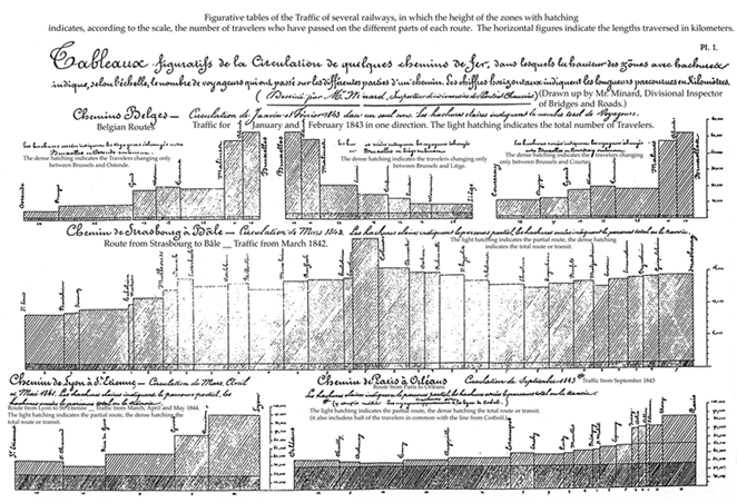 Table I The following year, in 1845, I published in the
same system the first graphic table which had appeared on the commerce of the canal du Centre, and of which Table III
is the copy. In this one the rectangles
refer to diverse merchandise having different colors. This lithographed and colored graphic table was distributed at
the end of 1845 to a number of people, engineers, deputies, etc.[2] This method of representation has a small
disadvantage with regard to commercial exploitation: sometimes the journey of
the goods cannot be followed easily by the eye, because the rectangles of the
same color which represent it are separated by those of another color; and if
one really wants to understand the movement of these goods, it is necessary to
have a graphic table for that alone. In this year, applying differently the same
system, I had arrived at figurative maps in which the rectangles of the graphic
tables are replaced by colored zones which follow the plan of the method of
transport and of which the widths are proportional to the traffic.
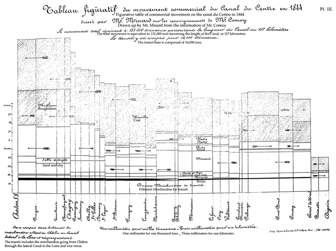 Table III In March 1845 I published my first figurative map,
related to the discussion of the project of the railway from Dijon to Mulhouse;
Table II is a copy of it. The travelers
circulating on the routes of the country, taken up between the two cities, were
represented there by the colored zones which follow the contours of these
routes and which have widths proportional to the number of travelers who passed
there in public coaches. Mr. Frémy,
then auditeur to the State Council, today
[2] counselor of the State and
governor of Crédit foncier had
carefully made of them a summary on the lines. My lithographed map in two hundred copies,
distributed to the members of the Council of Bridges and Roads, to the deputies
of the interested départements, to
engineers, etc. illuminates the discussion: the idea found there was so
pleasant in guiding opinion in the choice of a line in general, and in
particular of that which follows the valley of Doubs, that someone produced,
under my name, a forgery wherein he had drawn false zones in favor of a rival
line through the valley of Ognon. It is by sight alone that this map, which was
found to be eloquent, made visible the relationship between the numbers of
travelers, because it will be noticed that it does not carry a single numeral. To the advantage of an instantaneous evaluation of
the relationship of statistical results, the figurative maps adds the advantage
of judging them as a whole at a single glance, if they are contained in the
ordinary field of vision, at the same time keeping the lines in their
respective positions. Engineers seized these advantages with
alacrity. Some months after my
figurative map of the travelers between Dijon and Mulhouse appeared, several
engineers imitated it in order to support their railroad projects; among them
Mr. Reynard, for that from Grenoble to Valence[3],
Mr. Léon for that from Poitiers to la Rochelle[4],
Mr. Maillebiau for that from Bordeaux to Bayonne[5]
produced, in my system, figurative maps of the travelers circulating in these
districts.
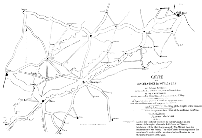 Table II Nevertheless, if my maps give immediately simple
relations like double, triple, etc., relations which, I repeat, are not
obtained by the numbers but by a little longer mental operation, this advantage
disappears if it is necessary to compare very disproportionate elements,
whereas with numbers, when the smallest has only two figures, with a little
time the mind can grasp the quotient; that is why I also write the numbers on
several of my maps. Moreover, the spontaneous evaluation of great
quantities has always been very uncertain.
Who knows the difficulty the general finds in numbering the enemy troops
who appear in his sight? Napoleon
himself affirmed that with his long experience, he was not sure he did not
mistake them by one quarter at least[6]. And yet nothing can say to the eye the
number of men better than the men themselves placed one next to the other. I do not know in the past of other expressive maps
other than those of the first geographers who drew the countries by their
animals. The application of algebra to the geometry of
Descartes gives us graphs representing geometrically the correspondence of two
variables; and the graphs of the tides were one of the most remarkable
applications of his discovery; I am unaware if anyone knows to whom they are
due. One sees there a progress in
graphic representation, since by the eye one knows the successive heights of
the tides. Applying to this representation of the tides is
the ingenious idea which Ons-en-Bray had, in 1734, to draw the graphic table of
the prevailing winds by using the wind itself acting on the mechanism. Thus was obtained, for our times, the tide
chart, an instrument which uses the sea [3]
itself to trace on the paper the hours and the successive heights of the tides,
creating the most complete and the most exact graphs of this movement. In the 18th century, we see the first
application, I believe, of the system of Descartes to phenomena without
determined law, like those of public economy, for example. Descartes drew the graphs after the
correspondence of two variables; one reverses the question, one looks to see if
the simultaneous facts, more or less correlative, recorded by abscissas and
ordinates, can correspond to known curves or give useful representations. One sees in the Tables of linear arithmetic by William Playfair[7]
printed first in London, later translated into French around 1787, the colored
graphs representing the annual prices of corn, the salary of factory workers,
etc. (Plate IV, fig. 2). At first glance, this one of the prices of corn
appeared similar to my graphic tables; there are rectangles, but their surfaces
have no statistical signification, while those of my rectangles, on the lines
of transport, enable one to see the number of tons carried in one kilometer, a
result so important for their trading, that one records it always in numbers in
the reports. In the beginning of the century, Layton Cooke
published his great tables of the colored graphs representing the annual prices
of corn in the north of Europe, those of wool, of meat, of butter[8],
etc. In 1826 I published, in the same system, the
diverse elements of the maintenance of the streets of Paris during the last two
centuries[9]. In 1833, again in the same system, Tarbé produced
tables of the deaths of journalists in Paris during the cholera of the
preceding year. The majority of engineers thus recorded the
diurnal heights of water of the rivers. These are, among many other applications, the ones
which were made and which are made still by extension of the system indicated
by Descartes; but it is well to remember that, since the elements of facts
collected simultaneously have no relation among them, like the qualities of
merchandise passing on a canal and the distances that they have traversed
there, the system of Descartes has no economic signification nor graphic
possibility, and it was necessary to find another method of representation of
statistical facts in order to compare them by sight alone. I heard it said, at the time of my maps, that it
had been a long time since someone had made expressive maps; not only do my
maps speak, but, even more, they count, they calculate, by the eye; this is the
chief point; this is the perfection that I have introduced in my figurative
maps by the width of the zones, and in my graphic tables by the rectangles. Other representations more or less unique have
appeared in these last years. Thus, we have grouped around a compass card, the
number of days where the same winds of a port have prevailed. (Plate IV, fig.
4). [4] In 1827, M. le Baron Ch. Dupin[10],
senator, and in 1828, Mr. Balbi and Mr. Guerry[11]
searched to show the degrees of instruction and of criminality in the départements by grey tints more or less
dark (Plate IV, fig. 4); this very ingenious representation has not been
imitated, without doubt because it does not give a numeric appreciation. One can well say that a tint is less dark
than another, this one sees. But to say
that it is two times or three times less, that is no longer seen, that is not
understood. As a method of counting by the tints, permit me to
cite, and only by analogy, the ingenious process of chemical analysis of waters
due, I believe, to Gay-Lussac. In twelve glasses containing the same quantity of distilled water, one dissolves increasing amounts of salt that is found in the water to be analyzed. One deposits there the same quantity of Reagent, so one has twelve precipitates of growing intensities. The same operation, made on the water to be analyzed, gives a precipitate that one can interpolate in the first group. One imagines that, in the same manner of operating, one will approach very near the equality of tints in two precipitates, that which will give the quantity of salt affected; but it is by the equality of the tint (which the eye does not mistake), and not by the different intensities, that one obtains a numeric solution. I return to graphic representations. Statisticians devise a circumference in 365 equal
parts, prolonging the radii going to these divisions, conveying outside, and
apart from the circumference, the proportional widths of the daily
observations; next unifying the extremities of these lines by a graphic curve,
they have a circular representation of the group of observations during the
year; in this way were drawn the daily revenues of the Western railroad in 1858[12]
(Plate IV, fig. 3).
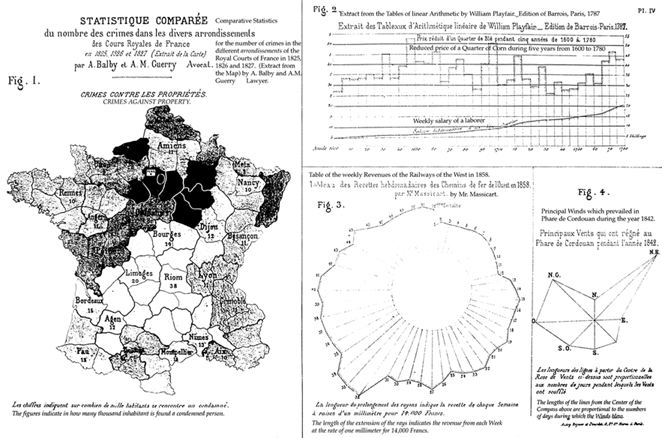 Plate IV I saw this mode of representation in the
statistics bureau of the Northern railroad, in 1846. In 1851, I employed the circles of proportional
surfaces in order to represent the production of coal-beds, and in 1852, in
order to represent the tonnages of the ports; this last representation
permitting placement of the ports with some geographic exactitude, one is able
to compare them for size and position. The representation by circles leaves much to be
desired. The mind perceives with
difficulty only by sight the connection of the surfaces of the two circles; it
is required, in some way, that the mind overlooks the valuation of the diameters
which the squares give in relationship to the circles. But if the separate circles compare badly, the
sectors of the same circle compare very well.
It is why I have chosen, in my map of the tonnages of the sea ports in
1857, to show through the sectors the relationships of the tonnages of each
port relating, one to the coasting trade, and the other to exterior commerce;
the sectors had been used already before I made use of them. In February 1847, Alphonse Belpaire, a Belgian
engineer, had published a notice on his beautiful figurative maps (without a
date) of roads, rivers and railways of Belgium, drawn absolutely in the same
system as that of my maps. He says in
this writing that his first map had appeared around [5] two years before the notice; this would be then around February
1845. But we know that it is at this
time that I had published my first figurative map. Thus, by admitting the assertion of Belpaire, the two inventions
surfaced at the same time in Belgium and in France. My publications have been imitated more or less
promptly. Having sent my colored
graphic table of 1845 on the commerce of the canal du Centre to Mr. Comoy, at that time charged with this canal,
this chief engineer found the idea so good that he continued it, and each year,
since 1851, he has produced graphic tables in imitation of mine[13];
there are only added, and always following my system, the representation of the
importance of the ports of the canal. By a circular of 20 December 1854, the
administration of bridges and roads recommended the application of the graphic
tables of Mr. Comoy (that is to say of mine) to the principal navigable lines,
and this prescription was followed. In 1856, Mr. Nicolas, engineer of bridges and
roads, brought together, in the form of interesting graphic tables, the
different circumstances of the exploitation of our railways since their
beginning. In 1857, Garella, engineer-in-chief of mines,
published a graphic table of the movement of travelers on the system of
railways of the West. One of the happiest applications of my system of
figurative maps was made in 1859 by the chief of railway statistics for the
Minister of Public Works; it shows the movement and the number of troops sent
to the war in Italy in 1859. Just recently the administration of bridges and
roads, adopting my system, prepared a large figurative map in twelve pages on
the traffic of imperial routes in 1856-57. After some years the railroad companies have
adopted my graphic tables in order to represent their traffic of slow trains. The company of Orleans, considering my system from
a particular aspect, deemed it excellent from the point of view of railway
administration; but it did not seem fit to me to make known this modification. His Excellency the minister of agriculture, of
commerce, and of public works, upon the enlightened and benevolent presentation
of the director general of bridges and roads and railways, having been pleased
by the majority of my maps, I was able to publish to the number of almost ten
thousand copies. These included graphic
tables and figurative maps on diverse subjects such as the traffic of travelers
on the roads and railways, merchandise in general, and in particular of coal,
grains, and wines, on the waterways and railways; the tonnages of sea ports of
France, of the sea ports of Europe and of the globe, the consumption of meats
of butcher’s shops in Paris, the merchandises passing in transit by way of
France, and lastly the importation of raw cotton in Europe, etc. etc. My figurative maps and my graphic tables having
been presented to the Emperor, His Majesty [6]
well wished, in accepting them, to make me know “that he had regarded them with
interest and that he would make use of them[14].” Strengthened by this august commendation given to my publications so well received in France and abroad, I feel, at more than eighty years, the satisfaction of having given birth in my old age to a useful idea, of having spread it by way of numerous applications, and of thus rendering again some service at the end of my career. Paris, 1 December 1861. [7] [1] Ars magna lucis et umbrć, by Kircher. Rome, Luis
Gringnani, 1656. — Discours de la méthode
de Descartes [Treatise on the method
of Descartes], Paris, Louis Legras, 1650. [2] It is of this table that Mr. Teysserene, deputy of the Hérault, to whom I had given it, said,
in his Études sur les voies de
communication [Studies on the means
of communication], printed in 1857: “The Inspector general Mr Minard has
published a graphic table on the commercial movement of the canal du Centre which indicates at once
the tonnage, the direction of movement and the length of the routes of the
different kinds of merchandise, etc.” (Page 657 of the proofs). It is also this table of which Mr. Comoy, to
whom I had addressed it, spoke in the memoir inserted in the Annales des ponts et chausses [Annals of bridges and roads]. March and April 1853, p. 175. [3] Memoir and report of the middle of 1853. [4] Ibid. 20 August 1855. [5] Ibid. January 1856. [6] Histoire du Consulat et de
l’Empire [History of the Consulate and the Empire]
by Mr. Thiers, t. XVI, p. 533. [7] Printed in London, by W. Sams, James’s street, number 1, translated
into French, edition of ...... Barrois, Paris, 1787...... (at the Imperial
library). [8] London, 69 Great Russel street, Bloomsbury square. [9] Projet de canal et de chemin de
fer pour le transport de paves ŕ Paris [Project to bring
paving stones to Paris by canal and railway]; by Delaforest, rue des
Noeyers, 37, Paris, 1826. [10] Pl. I, from Forces productives
et commerciales de la France [Productive
and commercial forces of France]. [11] Paris, by Jules Ronouard, rue de Tournon, number 6. [12] Unpublished lithographic table, by Mr. Massicart. [13] When two of these tables were sent to the universal exhibition of
1855, I had to reclaim my precedence.
It was recognized by the international jury, which expressed itself
thus, page 436, of their published report: “Next to these beautiful models
exhibited by the minister of public works are found: 1 . . . . . . . 2 the
graphic tables of the traffic on the canal
du Centre in 1852 and 1853, drawn up by the engineer-in-chief Comoy, after the system that Mr. Minard, inspector
general of bridges and roads in retirement, had imagined and applied to the
representation of the traffic on the railways in 1844, and on the canal du
Centre in 1845. Signed Mr. Wertheim, reporter.” [14] Just recently the map of the importation of cotton was put under the
eyes of the Emperor: “His Majesty examined it with a lively interest and showed
the intention of consulting it as necessary.”
|